Return to Platform
SERVICE_REGISTRY

Full GIS
Service Registry

A field-ops view of the services available across tenure management, acquisition, mapping, permitting, terrain modeling, and investor support.

Modules
10
Service Lines
63
Outputs
31
OPS_0106_LINES

Tenure Operations

Keep land positions active, traceable, and expansion-ready with staking, renewals, and title intelligence.

Outcome

Mineral tenure stays organized and ready for acquisition, exploration, or review.

Service Lines

Claim renewals and expiry tracking

Claim staking support and field-ready packages

Tenure research for Crown granted and patented mineral claims

Mineral claim ownership verification

Historical tenure research

Mineral claim due diligence

Typical Outputs
Tenure status summariesRenewal calendarsOwnership snapshots
OPS_0203_LINES

Acquisition & Brokerage

Support property acquisition strategy and circulate opportunities through an established investor network.

Outcome

Properties move faster from internal review to live investor conversations.

Service Lines

Property acquisitions and land position expansion

Property brokering for mineral opportunities

Marketing to a large network of investors

Typical Outputs
Acquisition briefsInvestor-ready map packagesMarket circulation support
OPS_0308_LINES

Mapping & Targeting

Build GIS products that combine tenure, geology, and prospecting logic into decision-ready map sets.

Outcome

Teams get one mapped surface for land review, targeting, and investor communication.

Service Lines

GIS mapping for planning and field operations

Mining claim maps and staking maps

Prospecting and target identification

Geologic, geophysical, and geochemical maps

Survey plan georeferencing

Parcel mapping and correction analysis

Property value comparison mapping

Spatial analysis for land and resource projects

Typical Outputs
Integrated GIS layersExploration target mapsTechnical map suites
OPS_0406_LINES

Permitting & Reporting

Prepare exploration paperwork and technical reporting so projects stay compliant and submission-ready.

Outcome

Regulatory steps are documented clearly and delivered in a format stakeholders can act on.

Service Lines

Permit applications

Notices of Work for mineral exploration and land use

Assessment Report preparation and submissions

Historical ARIS report research

Technical report support

QP geological reporting support

Typical Outputs
Permit application packagesNotice of Work support filesAssessment report submissions
OPS_0507_LINES

Terrain, Remote Sensing & LiDAR

Translate topography, satellite spectral imagery, and LiDAR into planning layers that improve terrain and alteration understanding before field deployment.

Outcome

Terrain context and spectral alteration targets become clearer for planning access, prospecting, and technical review.

Service Lines

Remote sensing and satellite spectral analysis (Sentinel NDVI, Iron Oxide B4/B2)

LiDAR analysis and Digital Terrain Models (DTM / DEM)

Topographic and contour mapping

Photogrammetry

Aerial photo sourcing and analysis

Terrain modelling for exploration projects

Virtual Tours (Panoramic Drone Photography) - client partner

Typical Outputs
Spectral alteration & NDVI mapsLiDAR DTM / DEM surface modelsOrthomosaic imageryAerial interpretation layers
Sample Work & Technical Case Studies
Real Field Data
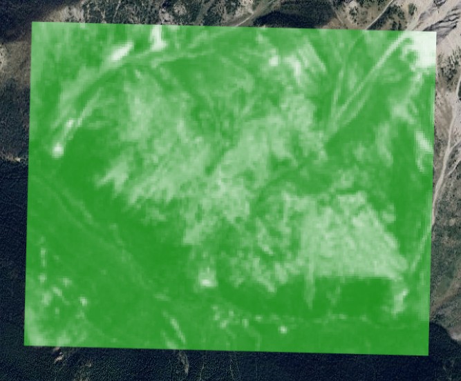
NDVI Spectral Analysis — Sentinel Imagery

NDVI Spectral Analysis — Sentinel Imagery

Normalized Difference Vegetation Index (NDVI) derived from Sentinel satellite imagery. Greener areas indicate healthy, dense vegetation cover.

BC MINFILE 082JSW018
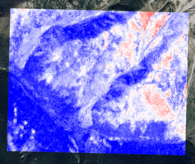
Iron Oxide Spectral Analysis (B4/B2) — Sentinel Imagery

Iron Oxide Spectral Analysis (B4/B2) — Sentinel Imagery

Band ratio (B4/B2) spectral analysis derived from Sentinel satellite imagery. Red zones highlight areas where iron oxide alteration is showing up strongest.

BC MINFILE 082JSW018
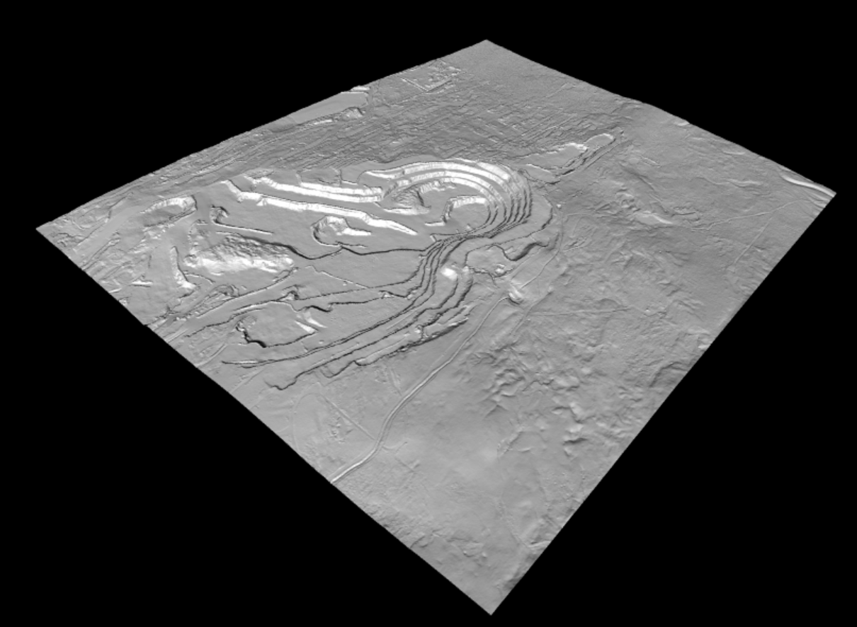
Digital Terrain Model (DTM) — LiDAR Derived

Digital Terrain Model (DTM) — LiDAR Derived

High-resolution bare-earth Digital Terrain Model (DTM) derived from LiDAR data for structural and topographic visualization.

BC MINFILE 093F 037
OPS_0606_LINES

Property Valuation & Assessment Appeals

Independent property valuation analysis supported by GIS research and assessment appeal expertise throughout British Columbia.

Outcome

Property owners receive defensible valuation evidence and support during assessment and tax appeal processes.

Service Lines

Property valuation reviews

BC Assessment appeals

Property tax appeals

Neighbourhood value comparisons

GIS-supported valuation analysis

Assessment evidence preparation

Typical Outputs
Property valuation reportsComparable property analysisAssessment appeal packages
OPS_0706_LINES

Property Due Diligence

Research and analysis services that help buyers, investors, and landowners understand property risks before making decisions.

Outcome

Clients gain a clearer understanding of property conditions, risks, and opportunities before acquisition.

Service Lines

Property Disclosure Statement reviews

Property history research

Land use review

Ownership investigation

Property acquisition support

Risk identification and analysis

Typical Outputs
Due diligence summariesProperty research reportsRisk assessment findings
OPS_0806_LINES

Title Searches & Ownership Research

Investigate ownership records, title history, and encumbrances to support informed property decisions throughout British Columbia.

Outcome

Clients receive a clear understanding of ownership status and title-related considerations.

Service Lines

Title searches

Ownership verification

Lien research

Property record investigations

Historical ownership research

Encumbrance identification

Typical Outputs
Ownership summariesTitle research reportsProperty record packages
OPS_0907_LINES

Boundary Disputes & Land Corrections

Resolve land boundary issues using GIS analysis, survey plan interpretation, georeferencing, and property research.

Outcome

Property owners and stakeholders receive reliable evidence to support land boundary and parcel correction matters.

Service Lines

Boundary dispute investigations

Survey plan analysis

Parcel correction research

Land correction order support

Georeferencing services

Property boundary mapping

ParcelMap discrepancy investigations

Typical Outputs
Boundary analysis reportsGeoreferenced survey mapsParcel correction documentation
OPS_1008_LINES

Geological & Technical Services

Support exploration projects with geological interpretation, technical reporting, and advanced spatial analysis.

Outcome

Exploration teams receive technical products that support decision-making, reporting, and project advancement.

Service Lines

Geological mapping

Leapfrog geological modelling

LiDAR interpretation

DEM analysis

Exploration targeting

Assessment report preparation

Technical report support

Qualified Person (QP) geological services

Typical Outputs
Geological mapsTechnical reportsExploration target models
Delivery Chain

Operational Flow

01

Define land status, tenure history, and immediate field objective.

02

Assemble the required GIS, imagery, terrain, and regulatory inputs.

03

Produce mapped outputs, filing packages, and investor-facing material.

04

Deliver a clean operating package for review, circulation, or submission.

Output Index
Tenure status summariesRenewal calendarsOwnership snapshotsAcquisition briefsInvestor-ready map packagesMarket circulation supportIntegrated GIS layersExploration target mapsTechnical map suitesPermit application packagesNotice of Work support filesAssessment report submissionsSpectral alteration & NDVI mapsLiDAR DTM / DEM surface modelsOrthomosaic imageryAerial interpretation layersProperty valuation reportsComparable property analysisAssessment appeal packagesDue diligence summariesProperty research reportsRisk assessment findingsOwnership summariesTitle research reportsProperty record packagesBoundary analysis reportsGeoreferenced survey mapsParcel correction documentationGeological mapsTechnical reportsExploration target models
Next Action

Need a tailored scope, a property review, or a field-ready mapping package? Open a direct channel and outline the land position, region, or exploration objective.

Start Contact Protocol