
Dalvine East Property - British Columbia
Document Dossier Summary
EXECUTIVE CONTENT OVERVIEW
Select any section below to jump directly to detailed findings:
Property Overview & Regional Setting
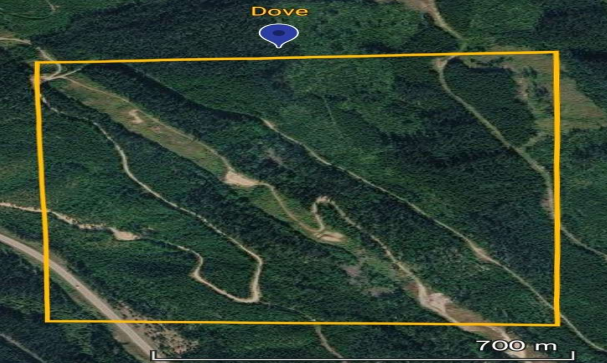
Satellite overview of the Dalvine East property[cite: 33].
The Dalvine East Property is a compact 17.06-hectare early-stage exploration project situated within the Intermontane tectonic belt and Stikine terrane in northern British Columbia[cite: 31, 32]. The property encompasses the historic Upper Gnat Creek occurrence, located on a ridge approximately 1.5 kilometres south of Upper Gnat Lake in the Liard Mining Division[cite: 32]. The broader region forms part of the highly prospective Golden Triangle, characterized by extensive Mesozoic intrusive and volcanic activity that has produced numerous porphyry, intrusion-related, vein, and hydrothermal mineral systems[cite: 32].
Project Highlights
- Compact 17.06-hectare target located in the Golden Triangle exploration district[cite: 31, 38].
- Structurally controlled I06 Cu±Ag Quartz Vein mineralization hosted in Upper Triassic Cake Hill plutonic rocks[cite: 31, 34].
- Significant polymetallic assays from massive sulphide breccia, including 1.7 g/t Au, 82 g/t Ag, >1% Cu, and 483 ppm Bi[cite: 31, 35].
- Peak historical selected grab sampling yielded 14.94% Cu, 7.50 g/t Au, and 117.1 g/t Ag from massive chalcopyrite[cite: 31, 35].
- Mineralization is accompanied by strong potassium-feldspar alteration, brecciated wall rocks, and copper oxide staining[cite: 34, 36].
- Additional historical copper-sulphide-bearing veinlets documented 140 metres southeast along the ridge, indicating broader system potential[cite: 35].
Geological & Structural Architecture
The property is principally underlain by intrusive rocks of the Upper Triassic Cake Hill pluton, a component of the Jurassic-Triassic Hotailuh batholith[cite: 34]. Intrusive lithologies include hornblende quartz monzonite, granodiorite, and rare hornblende diorite[cite: 34]. Regional mapping immediately west of the Upper Gnat Creek showing indicates the presence of Upper Triassic Stuhini Group volcanic rocks, consisting of andesite, basalt flows, tuff, and breccia[cite: 34]. The juxtaposition of these intrusive rocks with Stuhini volcanics, combined with strong hydrothermal alteration and sulphide-bearing structures, creates a highly favourable environment for Cu-Au-Ag exploration[cite: 34].
Mineralization & Hydrothermal Alteration
Mineralization conforms to the I06 Cu±Ag Quartz Veins deposit model, typically developing within faults, fractures, and shear zones[cite: 34]. At Upper Gnat Creek, a gossanous, oxidized, and chlorite-altered diorite to monzodiorite hosts quartz stringers and veins containing chalcopyrite, bornite, and pyrite[cite: 34]. Sulphides locally occur as massive mineralization within quartz veins ranging from 1 to 10 centimetres wide, and the mineralized zone reportedly widens locally into a 20 m x 20 cm pod[cite: 34]. Strong potassium-feldspar alteration halos encircle portions of the mineralized veins[cite: 34, 36]. The strong association of Cu-Au-Ag with elevated Bismuth provides a vital geochemical vector for mapping hydrothermal zoning[cite: 36].
Historical High-Grade Assays (2011-2012)
| Year | Sample Material | Cu (%) | Au (g/t) | Ag (g/t) | Bi (ppm) |
|---|---|---|---|---|---|
| 2011 | Massive sulphide breccia | >1% | 1.7 | 82 | 483 |
| 2012 | Massive chalcopyrite vein | 14.94% | 7.50 | 117.1 | — |
Historical Exploration & Geophysics

MINFILE Inventory Detail Report for Upper Gnat Creek (104I 149)[cite: 35].
Modern exploration of the broader historical Galaxie property included significant regional programs[cite: 37]. In 2011, Finsbury Exploration Ltd. executed a large soil and silt sampling program that successfully identified the massive sulphide breccia at Upper Gnat Creek[cite: 37]. In 2012, Quartz Mountain Resources Ltd. followed up with systematic soil geochemistry and induced polarization (IP) geophysical surveys over high-priority grids[cite: 37]. Because the known chalcopyrite, bornite, and massive pyrite mineralization may produce distinct chargeability responses, compiling and georeferencing this historical IP data against the current 17.06-hectare property boundary is a primary target for future verification[cite: 37].
Acquisition & Option Terms
Aurora Gold and Gravels Inc. is offering the Dalvine East Property to groups capable of advancing the project through systematic exploration and drill testing. Deal structures include 100% outright acquisition via negotiated cash and/or share payments, or a staged option-to-purchase agreement earning up to 100% through milestone cash payments, share issuances, and funded exploration expenditures. The vendors require a retained Net Smelter Return (NSR) royalty (e.g., 2%), with all commercial terms, purchase prices, and buyback provisions open to negotiation prior to a definitive agreement.
Quick Facts
- PropertyDalvine East (Upper Gnat Creek / Galaxie)
- MINFILE Number104I 149
- Mining DivisionLiard
- Area17.06 Hectares
- Primary CommoditiesAu, Ag, Cu, Bi
- Deposit TypeI06 - Cu±Ag Quartz Veins
- StatusShowing / Early-Stage Exploration