
Dove Property - British Columbia
Document Dossier Summary
EXECUTIVE CONTENT OVERVIEW
Select any section below to jump directly to detailed findings:
Property Overview & Regional Setting
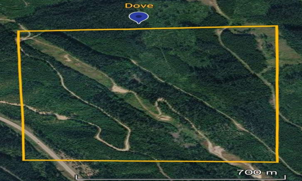
Satellite overview of the Dove Property[cite: 24].
The Dove Property is a gold-copper-silver exploration project covering approximately 78.50 hectares in east-central British Columbia, roughly 24 kilometres southeast of Valemount[cite: 24]. The location benefits from proximity to the Yellowhead Highway corridor, providing established transportation infrastructure, accommodation, and supplies[cite: 25]. Situated within the Omineca tectonic belt, the property is underlain by Ancestral North America rocks and encompasses the historic Dove/Ingrid mineral occurrence[cite: 24, 25].
Project Highlights
- Compact 78.50-hectare project centered on a known gold-copper-silver system with documented native gold[cite: 24, 29].
- Historical surface sampling returned maximum individual values of 8.64 g/t Au, 60.5 g/t Ag, and 1.82% Cu[cite: 24, 27].
- Mineralization occurs in two vertically adjacent structurally controlled zones and two stratiform units within the Malton Gneiss Complex[cite: 24].
- Extensive historical database including over 300 metres of diamond drilling across at least 17 holes (1978, 1983, and 1987 programs)[cite: 28, 29].
- Strong structural control model indicating mineralization is localized at intersections between mafic-rich metamorphic units, deformation zones, and quartz veining[cite: 26].
Geological & Structural Architecture
Regionally, the area is underlain by Upper Proterozoic metamorphic rocks of the Malton Gneiss Complex[cite: 25]. The dominant local lithologies include quartz-mica schist, amphibolite, and hornblende gneiss, all of which contain massive white quartz veins and stringers[cite: 25]. The sequence has undergone polyphase folding, resulting in a west-northwest-trending regional fold axis[cite: 25]. The nearby North Thompson Valley fault is a major regional structural feature[cite: 25]. Structure is a critical control on mineralization at Dove: gold and copper occur along fractures, foliation surfaces, and within quartz veins localized in deformed, less competent mafic-rich metamorphic zones[cite: 25, 26]. Encouraging historical values were noted along a trend of slickenside lineations, confirming late-stage structural emplacement[cite: 25].
Mineralized Zones
- Lower Mineralized Zone: An approximately 70-metre-long exposure with a 3-metre reported width[cite: 26]. Hosted in quartz veins, hornblende-quartz gneiss, and biotite schist[cite: 26]. 1987 sampling returned 0.10 to 8.64 g/t Au, 0.2 to 51.9 g/t Ag, and <0.01% to 1.82% Cu[cite: 26].
- Upper Mineralized Zone: An approximately 20-metre exposure with a 4-5 metre reported width[cite: 26]. Comprises quartz veins, hornblende-biotite-quartz gneiss, and mica schist[cite: 26]. Historical samples returned 0.18 to 7.45 g/t Au, 0.1 to 60.5 g/t Ag, and 0.01 to 1.77% Cu[cite: 26, 27].
- Stratiform Units: Two additional mineralized stratiform units were identified during historical diamond drilling[cite: 24, 26].
Historical High-Grade Assays
| Sample Year / Type | Au (g/t) | Ag (g/t) | Cu (%) |
|---|---|---|---|
| 1986 - Epidote/Hornblendite Rock Sample | 8.30 | 28.3 | >0.5% |
| 1987 - Maximum Individual Samples | 8.64 | 60.5 | 1.82% |
Historical Exploration & Drilling Summary
Exploration in the area dates back to the early 1970s with regional stream-sediment sampling by Hudson's Bay Minerals[cite: 28]. Following the discovery of malachite during hydro-line construction, the Ingrid claims were staked in 1978 and tested with two short diamond drill holes (~20 metres total)[cite: 27, 28]. A subsequent 7.5-metre hole was drilled in 1983[cite: 27]. The most comprehensive program occurred in 1987, consisting of 14 diamond drill holes totaling 283 metres, geological mapping, soil/rock geochemistry, and 6 kilometres of ground magnetics[cite: 27, 28]. Collectively, the drilling confirmed mineralization over an area of approximately 200 square metres[cite: 27, 29]. Because historical records suggest the irregular presence of coarse native gold (the 'nugget effect'), future evaluation should employ larger sample volumes and metallic-screen fire assays[cite: 28].
Acquisition & Option Terms
The Dove Property is offered by Aurora Gold and Gravels Inc. for outright purchase or through a staged option agreement[cite: 30]. An outright 100% acquisition is available via negotiated cash and/or share payments subject to a retained Net Smelter Return (NSR) royalty[cite: 30]. Alternatively, an earn-in option structure can be negotiated combining cash payments, share issuances, and funded exploration commitments[cite: 30]. The vendors propose a 2% NSR royalty as part of the transaction, with all buyback provisions and commercial terms subject to a definitive agreement[cite: 30].
Quick Facts
- PropertyDove / Ingrid
- Mining DivisionCariboo and Kamloops
- Area78.50 Hectares
- Primary CommoditiesAu, Cu, Ag
- Deposit TypeStructurally Controlled Vein / Stratiform
- StatusEarly-Stage Exploration (Drilled)
- Location~24 km SE of Valemount, BC