
HB / Garnet Property - British Columbia
Document Dossier Summary
EXECUTIVE CONTENT OVERVIEW
Select any section below to jump directly to detailed findings:
Property Overview & Location
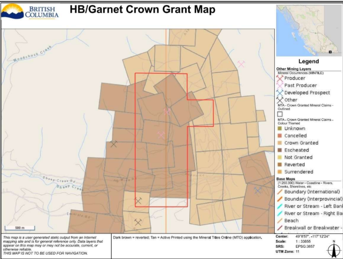
HB/Garnet Mineral Claim (Tenure 1109085) and Crown Grant Map (MTO/MTA overlay).
The HB/Garnet Property is a past-producing zinc-lead-silver polymetallic project located approximately 8 km southeast of Salmo, British Columbia, within the historic Salmo-Sheep Creek mining district. Covering approximately 232.42 hectares under mineral tenure 1109085, the property encompasses the historic HB Mine and Garnet mineralized trend. The project benefits from excellent infrastructure, accessed from Salmo via Airport Road, Sheep Creek Road, and the Woodchuck Forest Service Road, with nearby power, local workforce, and essential services.
Project Highlights
- Past-producing polymetallic mine property covering 232.42 hectares in the prolific Salmo-Sheep Creek mining camp.
- Substantial documented historical production of ~6,656,101 tonnes of ore mined across 29 operating years between 1912 and 1978.
- Extensive cumulative metal recoveries: 260.43M kg Zn, 49.51M kg Pb, 29.43M g Ag, 2.02M kg Cd, 105,412 kg Cu, and 6,159 g Au.
- Includes both deep underground workings (HB Mine) and open-pit development (Garnet orebody).
- High-grade modern 2026 rock sampling yielding up to 10.16% Pb, 3,413 g/t Ag, 0.70% Cu, and 1.07% Sb (Sample HB3).
- Stratabound and structural carbonate-hosted mineralization with pencil-like ore shoots extending up to 900 metres down plunge.
- Turnkey road access 8 km from Salmo with intact logging and forestry road infrastructure across the claim.
Historical Production Summary (1912–1978)
| Commodity | Recovered Metal | Imperial / Equivalent Units |
|---|---|---|
| Zinc (Zn) | 260,430,000 kg | 260.43 million kg (~574.15M lbs) |
| Lead (Pb) | 49,510,000 kg | 49.51 million kg (~109.15M lbs) |
| Silver (Ag) | 29,430,000 g | 29.43 million g (~946,200 oz) |
| Cadmium (Cd) | 2,020,000 kg | 2.02 million kg (~4.45M lbs) |
| Copper (Cu) | 105,412 kg | 105.41 tonnes (~232,400 lbs) |
| Gold (Au) | 6,159 g | 6.16 kg (~198 oz) |
Historical Mine Operations & Infrastructure
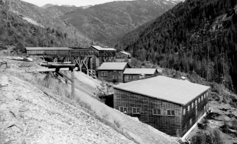
Historical surface works and mill plant facility at the HB Mine site.
The HB Mine was developed as a substantial multi-level underground operation, while the nearby Garnet orebody, situated southwest of the main HB underground workings, was exploited from surface via an open pit. Mining ceased in 1978 with historical measured and indicated reserves documented at closure. Extant access routes and historic bench/adit positions offer direct entry points for modern structural evaluation and geotechnical appraisal.
Geological & Structural Architecture
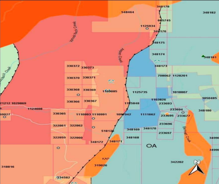
Bedrock geology map showing the Reeves Member carbonate belt west of the Active Formation thrust fault.
The HB/Garnet Property is predominantly underlain by carbonate strata of the Lower Cambrian Laib Formation (Reeves Member), comprising limestone with widespread, variable dolomitization. The mineralized sequence sits immediately west of a major regional thrust fault that juxtaposes the Laib Formation against Lower to Middle Ordovician Active Formation argillites. Severe polyphase deformation has produced tight folding, shearing, brecciation, and structural thickening. Key hydrothermal alteration assemblages associated with high-grade mineralization include strong dolomitization, silicification, and pervasive talc-tremolite development, which serve as crucial vectors for systematic exploration.
Deposit Mineralization Styles & Zonation
- HB Steep Pencil Shoots: Primary hypogene mineralization consists of sphalerite, galena, pyrite, and pyrrhotite with silver, cadmium, copper, antimony, and local gold. Three steeply dipping, subparallel zones plunge continuously for roughly 900 metres, with the largest historical shoot reaching 140 m vertical height and 30 m maximum width.
- HB Cross-Cutting Breccia Zones: Flatter-lying stratabound breccia layers ranging from 3 to 5 metres thick (locally up to 12 metres). The richest mineralized shoots developed precisely at the intersections of steeply dipping shear zones with these low-angle breccia horizons.
- Garnet Open-Pit Zone: Located southwest of the HB portals, featuring fine-grained sphalerite, pyrite, and minor galena disseminated and banded within dolomite. The primary Garnet zone is ~15 metres wide, outcropping between 1,050 and 1,160 metres elevation, roughly 50 metres west of the Garnet Fault.
- Lucky Boy Showing: Located near the base of the Reeves Member, hosting disseminated, banded, and massive sphalerite lenses across intervals of 0.3 to 5.0 metres (historical core intercept: 4.7% Zn over 0.5 m with Pb, Ag, and Cd).
2026 Surface Exploration Assays
| Sample ID | Pb (%) | Ag (g/t) | Cu (%) | Zn (%) | Sb (%) | Cd (ppm) | Te (ppm) | Key Notes |
|---|---|---|---|---|---|---|---|---|
| HB3 | 10.16% | 3,413 g/t | 0.70% | 0.45% | 1.07% | 84.9 | 14.2 | Also returned 602 ppm As; ultra-high silver/lead tenor |
| HB1 | 0.26% | 2.24 g/t | — | 0.67% | — | 24.6 | — | Returned 23.4% S; massive sulphide indicator |
| HB2 | 0.027% | 150 g/t | 0.0079% | 0.0585% | — | — | 85.9 | Significant tellurium and silver enrichment |
Selective Mineralized Specimen
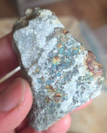
Polymetallic sulphide rock specimen showing galena, sphalerite, and secondary oxidation.
Recent geochemical verification highlights high-grade polymetallic mineralization outcropping at surface. In particular, sample HB3 demonstrated strong precious-metal concentration (3,413 g/t Ag) alongside massive base-metal enrichment (10.16% Pb, 0.70% Cu, 0.45% Zn, 1.07% Sb) and trace tellurium/arsenic, confirming an active epithermal-to-replacement precious-metal overprint within the broader carbonate system.
Commercial Acquisition & Option Terms
Aurora Gold and Gravels Inc. is making the 232.42-hectare HB/Garnet Property available for acquisition or staged farm-in/option. The vendors are seeking an exploration team with the capability to execute modern geophysical surveys, 3D structural modeling of the historic workings, and drill testing. Deal structures available include: (1) Outright Purchase for cash and/or equity consideration subject to a retained Net Smelter Return royalty; or (2) Staged Option-to-Purchase earning up to 100% through milestone cash payments, share issuances, and funded exploration expenditures. The vendors propose a 2.0% NSR royalty with standard buyback options subject to mutual agreement. Contact: chris@miningpropertymaps.com, Aurora Gold and Gravels Inc., Bella Coola, BC.
Quick Facts
- PropertyHB / Garnet Mine
- Tenure Number1109085
- Mining DistrictSalmo-Sheep Creek (Nelson Mining Division)
- Area232.42 Hectares
- Primary CommoditiesZn, Pb, Ag, Cd, Cu, Au
- Deposit TypeCarbonate-Hosted / Kootenay Arc Zn-Pb (Manto / Replacement)
- StatusPast Producer / Advanced Exploration
- Historical Production6,656,101 tonnes (1912–1978)
- Owner / VendorAurora Gold and Gravels Inc.